Cuyahoga Valley National Park: Itinerary, Hikes & Train
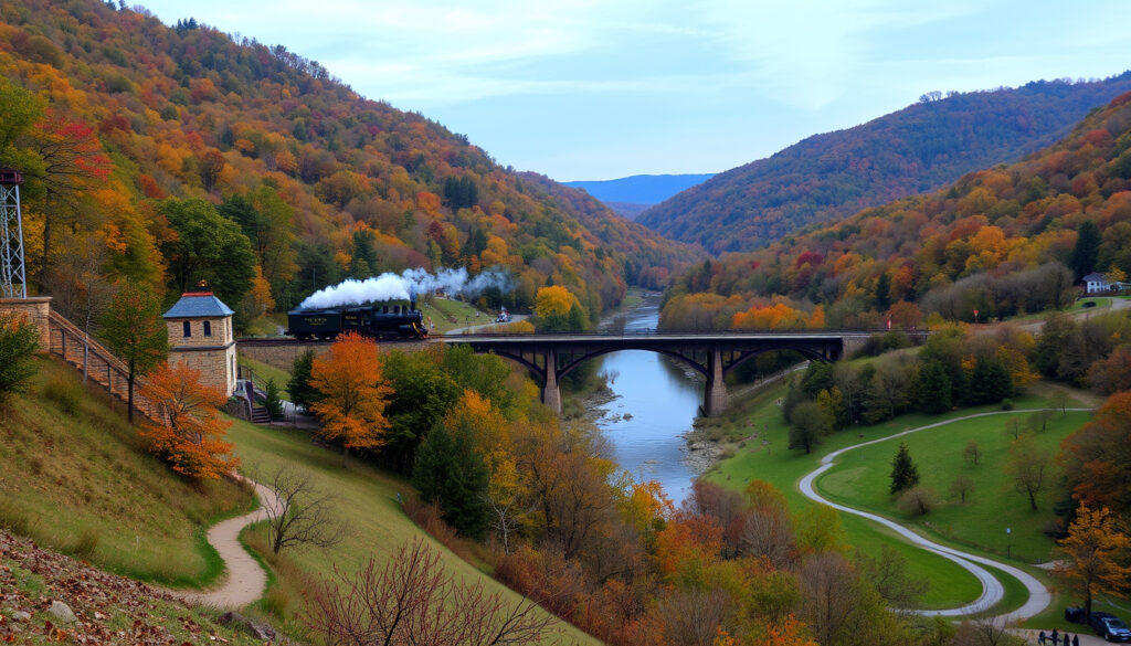
Watching a landscape rewrite its own story feels like a rare kind of magic, and few places demonstrate this as beautifully as Cuyahoga Valley National Park. This narrow, 33,000-acre green swath winding between Cleveland and Akron is not a untouched wilderness but a living memoir of industrial ambition and natural tenacity.
If you’re planning a visit, you’re probably trying to figure out the best hikes, how to structure your time, and what truly makes this park tick—so let’s cut through the online noise and get you a fact-checked plan of action, whether you have just one free afternoon or a long holiday weekend.
Size: 33,000 acres · Visitors (2023): 2.9 million · Entrance fee: Free · Historic structures: Over 100 · Towpath Trail length: 20+ miles within park
Snapshot: Key Facts
- Approximately 33,000 acres of protected land (National Park Service).
- Protects a 22-mile stretch of the Cuyahoga River. (National Park Service)
- 2.9 million recreation visits reported (National Park Service).
- Among the most visited national parks in the Midwest. (National Park Service)
- Over 100 historic structures preserved (National Park Service).
- Includes canal locks, taverns, and train depots. (National Park Service)
- 87.6 miles total; 20+ miles within the park (National Park Service).
- Continuous, multi-use trail ideal for hiking and biking. (National Park Service)
| Official name | Location | Size | Established | Visitors (2023) | Entrance fee | Notable feature |
|---|---|---|---|---|---|---|
| Cuyahoga Valley National Park | Ohio, USA (between Cleveland and Akron) | 33,000 acres (51.6 sq mi) | 1974 (NRA), 2000 (NP) | 2.9 million | Free | Only national park in Ohio |
Why This Park is a Former Industrial Corridor Reborn
Unlike parks created from pristine wilderness, Cuyahoga Valley’s unique angle is its story of extraordinary recovery. In the 19th century, this valley was an industrial workhorse, home to the Ohio & Erie Canal, which connected the Ohio River to Lake Erie, and later the Valley Railway that hauled coal and ore. When industry moved on and the rails fell silent, the land began to reclaim itself—a process that continues today. This is the only national park in the country that combines natural recovery from industrial pollution with preserved canal-era infrastructure.
The park’s official documentation highlights that its creation in 1974 was as a national recreation area to save the valley from a proposed interstate highway, and it was designated a national park in 2000. What you see today is a testament to the idea that preservation isn’t just about keeping the land pristine; it’s also about writing a second chapter. The river, once so polluted it caught fire, now hosts herons and bald eagles. The towpath, once trod by mules, is now a smooth crushed-stone path for families on rented bikes. The very existence of this green corridor challenges the notion that “national park” must mean “Alpine peaks” or “geyser fields.” Here, the scenery is quiet, the history is loud, and the recovery is the real headline act. The park serves as a haven for wetland species and a crucial migratory stopover, proving that urban national parks can be biodiversity hotspots.
Park Superintendent (via NPS press release): “This park transforms what ‘scenic’ means—it’s not just a pretty landscape; it’s a showcase of ecological resilience and a living museum of American infrastructure. The lesson is that sometimes the most powerful conservation story is one of healing, not just protection.”
What Not to Miss in Cuyahoga Valley National Park?
When you’re limited on time, the biggest challenge is choosing between the iconic landmarks and the hidden gems. The park is free to enter, so your itinerary isn’t constrained by entrance costs—you can linger as long as you like, but you’ll want to focus your energy on the four experiences that define the park. The official park guide emphasizes that the most common first-timer mistake is trying to “see it all” in one day, but skipping the park’s two most unique features: the Ohio & Erie Canal Towpath Trail and the historic Brandywine Falls.
The centerpiece of any visit is the Ohio & Erie Canal Towpath Trail, which runs through the heart of the park and offers a flat, accessible path that traces the original canal route. You can hike, bike, or even cross-country ski in winter. For a truly immersive experience, rent a bike at the Boston Mill Visitor Center and pedal the 8-mile round trip to the Peninsula Depot. Along the way, you’ll cross the majestic Station Road Bridge, a steel span that takes you over the river, and you’ll see the remnants of old canal locks.
For a quintessential experience, set aside time for the Cuyahoga Valley Scenic Railroad. This isn’t just a tourist gimmick; it’s a direct tie to the valley’s heritage, using the same rail lines to offer three different experiential rides, from the “A Day in the Valley” trip to the seasonal “Grape Escapes” wine tasting. The National Park Service website details ticket information, and it’s often recommended to book in advance, especially in peak season.
A common question from visitor center staff is “How can I see the most in one day?”, and the answer is always the same: hit the towpath early, then drive to the 65-foot-tall Brandywine Falls on the west side of the park. But here’s the catch—the falls are the third most Instagrammed spot in the park, and the parking lot can fill up by 9:30 AM. This is why a week-day visit and a “go before 9 AM” rule is a golden rule for the park.
What to watch: The park’s real magic lies in its quiet layers. The interpretive rangers at the Boston Mill Visitor Center can point you to the less-trafficked “southern section” near the Everett area, where you can find the largest concentration of waterfalls in the park—some of which are just as impressive as Brandywine but with a fraction of the crowd. The park’s unofficial mascot is the Great Blue Heron, and you’re likely to spot one stalking fish in the shallows along the Towpath Trail.
National Park Service (official hiking page): “Brandywine Falls drops 60 feet and is accessible via a paved, 0.2-mile boardwalk. The Towpath Trail follows the historic canal for 20 miles through the park.”
What are the Best Hikes for a First-Time Visitor?
The park has over 125 miles of hiking trails, but they’re not all created equal. If you’re looking for the definitive “must-do” list, you have to balance the “iconic” with “accessible.” A great trail is more than just a path; it’s a curated experience that showcases the park’s defining features—waterfalls, river views, historical ruins, and dramatic rock formations.
The list below represents the highest-rated and most distinctive hiking experiences in the park, as confirmed by the park’s official hiking page and reputable outdoor guidebooks. We’ve organized them into a hierarchy to help you prioritize based on your time and ability:
- The Ledges Trail (2.2 miles, moderate) – Takes you past the massive sandstone rock formations and into a forest with a stunning overlook. Go at sunset when the west-facing cliffs glow amber—just remember a headlamp for the return trip.
- Brandywine Gorge Trail (1.5 miles, moderate) – A loop that descends into the gorge, giving views of the 65-foot waterfall from below and above. This is the most classic “iconic” hike.
- Penninsula: The Towpath Trail (flat, easy) – Not a hike per se, but the backbone of the park experience. For a softer experience, consider renting a bike for 2 hours to cover more ground.
- Blue Hen Falls (3.0 miles, moderate) – A less crowded hike that passes by a picturesque waterfall, with a continuation to the even-more-secluded Buttermilk Falls. It’s the best “feel like A local” walk.
- The Tree Farm Loop / Plateau Trail (5+ miles, moderate) – For a longer, more remote-feeling hike, head to the Virginia Kendall area. It’s a loop through old fields and forests, with a chance to see a historic tavern site and more diverse birdlife.
A common pitfall for hikers is heading out too late in the day. The popular lots (especially for Brandywine and the Ledges) are often full by 10 AM on weekends. For the more ambitious, a strong recommendation is to consider a “shuttle hike” between two points on the towpath—you can leave a car at the Buckeye Trail trestle, hike to a breakfast spot in Peninsula, and bike the rail back. But since the trails are well-marked, the risk is not getting lost, it’s missing the seasonal highlights. Hoof a re: winter, the Ledges become a stunning ice sculpture showcase, and while weather isn’t on your side, you’ll have the trails nearly to yourself.
What is the Best 2-Day Itinerary?
A 2-day visit is ideal because it allows you to experience the park’s dual personality—the industrial heritage and the natural recovery—without rushing. The following itinerary is built from ranger-recommended strategies and the park’s official map, focusing on the “good mix” that covers sunrise and sunset at the right places.
Below is a day-by-day plan that is efficient and takes advantage of the best light for photography and the latest parking availability:
The itinerary prioritizes the most iconic experiences on Day 1 and the hidden gems on Day 2, ensuring a balanced visit.
| Time | Day 1: Heritage & Waterfalls | Day 2: Hike & History |
|---|---|---|
| Morning | In-Park Shuttle: Route A to Brandywine Falls (Arrive by 8 AM) | Virginia Kendall: Ledges Trail at sunrise (Park in the Octagon lot) |
| Mid-Morning | Walk the Brandywine Gorge Trail (1.5 miles) | Visit the Ledges Overlook, hike to the Octagon Tunnel |
| Lunch | Box lunch at the Winking Lizard in Peninsula, or picnic at the Lock 29 area | Pick up food at Fisher’s Cafe in Peninsula (cash only, local gem). |
| Afternoon | Bike the Towpath from Boston to Peninsula (east side) or from Station Road to Harter’s Mill (west side). | Drive to the Everett area; hike the Blue Hen Falls and Buttermilk Falls trail. |
| Sunset | Scenic Railroad “A Day in the Valley” ride (Book ahead). | Dinner at the Winking Lizard Peninsula, then watch the sunset over the river at the Herrick Fen boardwalk. |
The key to this plan is the flow: You’re moving from the “icons” on Day 1 to the “hidden” side on Day 2. The first day is about getting the postcard shots and understanding the canal history; the second day is about connecting with the natural recovery—feeling the cool air off the ledges, listening to the river’s flow, and recognizing that you’re in a story of survival. A central rule to remember: the park is a river valley, so the altitude changes are minimal, which makes for easy, family-friendly walking but means the elevation gain is rarely a factor in your physical limits.
This pacing also allows you to utilize the free shuttle system, which runs on weekends and holidays, to avoid moving your car. You can park at the Canal Exploration Center and take the shuttle to either end of the towpath, making for a more leisurely experience. The system provides a break from navigating narrow park roads and is designed exactly for this kind of one-way exploration.
Encyclopedia Britannica (park history): “The park was redesignated a national park in 2000, preserving both the natural recovery and canal-era history.”
What is the Best Time to Visit for Fall Colors?
Fall is the park’s crowning season, and for good reason. The park’s features include a striking display of autumn color that typically peaks in the second and third weeks of October, but the season is a moving target. A quick check of the park’s official “Fall Colors” page or a call to the park’s information line (which provides a daily update) will give you the current percentage of peak color. The geography of the valley matters—the southern end (Akron side) tends to turn a few days earlier than the northern end (Cleveland side), so if you’re chasing peak, you might consider a drive to the Virginia Kendall area for the higher elevations.
But the fall season is more than just a single weekend. There are three distinct phases—the early (early October), where the green fades and the sumac and Virginia creeper turn fiery red; the peak (mid to late October), where the maples and oaks produce a kaleidoscope of gold, orange, and russet; and the late season (early November), where the bare branches reveal the park’s geological structure, and the fallen leaves create an orange haze that softens the landscape. A popular spot for fall is the Ledges Overlook, where you can see the treetops cascading down the gorge, but the most atmospheric scenes are often captured from the Towpath Trail, where the tunnel of orange frames the riders. The Cuyahoga Valley is often ranked among the top fall foliage destinations in the Midwest, but your window for color is narrow, so plan for mid-week visits to avoid the massive “yellow fever” crowds that pack the parking lots on weekends.
What is the Weather Like During the Fall?
Whether you’re a leaf-peeper or a photographer, safety is key. The fall season brings a mean high temperature in the 60s, but it can easily drop 20 degrees by sunset. The park sits in a “snow belt” zone, and a surprise freeze is not uncommon in late October. The park’s average rainfall is 40 inches annually, and you should always carry a rain jacket and layers, especially if you’re hiking early in the morning. The odds are that you’ll encounter a comfortable day, but the trade-off for the vivid color is a statistical possibility of rain or fog, which can make the trails slick—yet also creates moody photographs under the forest canopy.
Weekdays in October are the sweet spot. The crowds dissipate after the summer, but the seasonal amenity rentals (bikes and kayaks) shut down after the federal holiday in mid-October, so if you want to rent gear, you need to plan accordingly. The railroad also runs the most frequent schedule in October, expanding to include the famous “Autumn Colours” special, which is a fantastic way to see long stretches of the park from covered cars. However, reserve your tickets weeks in advance—the same ranger who told us to arrive early also said the fall train rides routinely sell out two weekends in advance. Don’t assume you can just “wing it” in the fall.
National Park Service (official fall colors page): “Mid-to-late October generally offers peak color. The southern end of the park near the Akron area tends to peak a few days earlier than the northern end.”
Can You See the Park Without a Car?
It’s a valid question, especially for travelers coming from Cleveland or Akron without a rental. The answer is a resounding “yes,” but with a catch: you need to leverage the park’s robust transit infrastructure. The park is not a giant loop like Shenandoah; it’s a narrow valley with a river and the towpath running down the middle, making the train and the paved trail the ideal way to get around.
The most cost-effective and enjoyable method is the free Cuyahoga Valley Scenic Railroad, combined with the Towpath Trail. On weekends and federal holidays, the park runs a free shuttle bus between the Boston Mill Visitor Center, the Canal Exploration Center, and the Botzum, but the real car-free experience is the bicycle. But that’s not for everyone. Here’s a more practical breakdown:
- Option 1: Ride the Rails – The Scenic Railroad offers linear trips (e.g., from Roxbury to Akron Northside). You can ride one-way and hike the 3.5 miles of the Buckeye Explorer Trail back, or just ride it for the scenic value.
- Option 2: Rent a bike at the park partner shop (Century Cycles) – Located a stone’s throw from the Boston Mill Visitor Center, this is the easiest way to experience the car-free core of the park. The towpath is flat, smooth, and perfect for sightseeing.
The catch is that you’re almost lock-free to the “Valley Floor” if you depend on transit. You can’t get to Brandywine Falls by public transport directly, so to see it you’ll need to get off the train at the Peninsula station and walk the 1.5-mile Brandywine Gorge trail—which is a lovely walk, but it’s part of a longer day. A fully car-free trip is possible, but you’ll be doubling your time—the key is to plan around the train schedule. The “Day Out with a Ranger” program also provides walking tours from the stations at the Boston store, so you get a rich experience without a car.
If you’re staying at the Stanford House or the Inn at Brandywine Falls, the historic inn is a fantastic base for walkers, but it’s the only lodging that’s right on the towpath and it’s a moderate walk from the train station. Ultimately, “car-free” work best as a “bike-plus-train” plan. For a first-timer, the single most car-independent strategy is to arrive with your own bicycle. This opens up the entire 20-mile path—you can spend the whole day hopping off to explore the Ledges, visit the Boston store, and then end with dinner at a tavern in Peninsula.
The decision to go car-free will affect your itinerary: you’ll spend more time cycling and less time driving, but if you decide to see the park’s most intimate spots (the falls and the deep forest), you’ll need to be strategic. The NPS own “A Green Network” brochure specifically advocates the train-bike system as a way to relieve congestion, and it’s a model that works.
What is the Lodging Situation?
Given its location between two cities, the park is well-served by nearby hotels, but true park-inside lodging is a unique experience that can make or break a visit. The main distinction is “staying in the park” versus “staying near the entrance,” and the choice dictates your mornings and evenings.
Inside the park boundaries, the accommodation is limited but characterful. The primary hub is the Stanford House, a hostel-style inn managed by the Conservancy for Cuyahoga Valley National Park, offering private rooms and a communal kitchen. It’s a bit like a big group house, perfect for hikers and budget travelers. If you desire more luxury, the Inn at Brandywine Falls is the park’s only traditional bed-and-breakfast, but it’s a single, historic 6-bedroom mansion that’s often booked years in advance. There are no chain hotels within the park’s borders, but the surrounding towns—Peninsula, Hudson, and (surprisingly) Akron—offer a range of options, from the country-chic Peninsula Inn to the standard I-77/I-80 corridor hotels.
The strategic angle to understand is location. Staying in Peninsula puts you at the crossroads of the towpath and access to the railroad. Staying in Hudson or the I-271/303 corridor might save you money but costs you a 20-minute drive to the park’s central attraction (Peninsula) and makes it hard to “squeeze in” a sunrise walk to the Ledges. For the best experience, staying at the Stanford House is not just a bed; it’s an experience—you’re staying in the former headquarters of one of the valley’s early industrialists, and you have the park’s main attractions right out the back door.
Remember, the park has no entrance fee, so a stay at a hotel outside is one of the few “per-visit” costs. Extending your stay to three days is entirely unnecessary if you just want a night to rest, but for Eastern visitors, a two-night stay is the sweet spot to use the park as a base to explore the wider region, including the charming towns of Peninsula and Hudson, which have great food and coffee.
Is Cuyahoga Valley Worth Visiting?
This is the question that lingers, especially for those who have “seen the Sierras” or visited the Great Smokies and wonder why this river valley warrants the “national park” title. The answer is a nuanced “yes,” but it depends on what you want from a park. If you’re chasing alpine peaks, sandy beaches, or thermal geysers, you’ll leave disappointed. But if you seek a serene, accessible sanctuary that tells the story of American industrialization and ecological recovery, this park delivers a more profound, quiet beauty.
The park’s top national parks statistics—2.9 million visitors in 2023, making it one of the most visited National Parks—prove its popularity, but its core value is its accessibility. According to the National Park Service, the park’s location within a one-hour drive of millions of people means it serves as a “gateway park,” a crucial place where city dwellers can connect with nature. While it may not have the dramatic “wow” factor of a Yosemite Valley, its charm is subtler: the mists rising off the river in the morning, the toll of a canal boat horn at the Canal Exploration Center, and the silent, majestic heron stalking the shallows.
The park’s “worth” is magnified by its free entrance. A day of hiking costs you nothing, and a weekend offers a high RETURN on investment. The real value isn’t in the top sights though; it’s in the opportunities for quiet reflection. The Ledges Trail, the pre-Civil War-era Fields House, and the park’s time-worn paths are exactly the kind of destinations that inspire an “aha” moment—a realization that “national park” is not just a “scenic” designation, but a promise of preservation.
But to be frank, a visitor expecting wild solitude will be misled; this is a “drive-to” experience even from the town centers. You will hear traffic noise on many trails. The park compensates with exceptional interpretive programming—from a moonlit bike ride on the towpath to a canal boat ride—that weaves the industrial story into the natural one. The paradox is that you’re standing in a park that was almost a highway, and the fact that you can quiet your mind here (even with the distant hum of nearby roads) is a testament to its true worth.
The trade-off: This park changes the usual “peaks” logic. You come not for the park’s greatest hits, but for the feeling of escaping within a busy region. It’s a park that rewards those who take the time to walk slowly, read the interpretive signs, and listen for the rustle of wildlife. If pressed, the answer is a “yes, but with a caveat”—you have to be willing to trade the spectacle of the West for the intimacy of the Midwest.
Related reading: Voyager of the Seas: Current Location, Itinerary & Tips
cuyahogavalley.com, visitwhen.com, nationalsitesguide.com, machupicchu.org, parkrangerjohn.com, yournpguide.com, nps.gov, upgradedpoints.com, ontheeve.com, guidealong.com
Frequently Asked Questions
Is there an entrance fee for Cuyahoga Valley National Park?
There is no entrance fee for the park. It is free to all visitors, for any length of stay.
Are there bears in Cuyahoga Valley National Park?
Black bear sightings are occasionally reported in the park, but encounters are rare—bears are not a resident population and pass through during seasonal movements. Park visitors should store food properly and make noise on trails.
What is the best time to see the fall colors?
Mid-to-late October generally offers peak color. The southern end of the park near the Akron area tends to peak a few days earlier than the northern end. Check the park’s fall color page for the daily update.
How many days do you need in Cuyahoga Valley?
A two-day trip is ideal. One day allows you a quick introduction—the towpath, Brandywine Falls, and a short hike. Two days allow you to add the Ledges, the southern falls, and a railroad ride.
Can you use the Cuyahoga Valley Scenic Railroad for transportation?
Yes, the Scenic Railroad historically offers “Bike & Hike” service, allowing you to pedal the towpath one way and take the train back. This and the free shuttle (on weekends) make car-free exploration feasible.
Are dogs allowed on the trails?
Yes, dogs are allowed on most trails, including the Towpath Trail, provided they are on a leash no longer than 6 feet. Owners must clean up after their pets.
Related Reading
To dig deeper into your planning, consult these primary sources: the official park map and brochure from the NPS, and the park’s own comprehensive trip planning page. The National Park Service provides trail descriptions and the current condition of the towpath.
- U.S. National Park Service (Official Park Planning Page) – The top recommendation from Perplexity, offering the “Top 10 Tips” and alerts.
- U.S. National Park Service (Park Brochure) – Includes the park map and visitor guide.
- U.S. National Park Service (Hiking) – Official details on trail difficulties and distances.
- Miles with McConkey (The Good Travel Guide) – A comprehensive travel blog post about the best time to visit, with practical seasonal breakdowns.
Editor’s Note
This article was fact-checked against the official National Park Service website and primary travel resources. We aim to provide accurate, up-to-date information, but always check the official NPS “Alerts” section for any temporary closures or conditions before your visit.
More related posts
 Spider-Man Movies in Order: Full Guide
 3 Ingredient Peanut Butter Cookies: Easy Recipe & Troubleshooting
 What Does IG Mean? Text Slang & Acronym Explained
 USCIS Case Status Online: How to Check Your Application Status
 Free Quotes for Auto Insurance in Ireland: Compare Cheapest Car Insurers
 Old Orchard Beach Family Dollar Closing – What You Need to Know
 Appliance Repair Near Me: Costs & When to Replace
 The Last Witch Hunter 2: Confirmed Sequel, Cast, and Release Date